Atherton, California
| Town of Atherton | |||
|---|---|---|---|
| — Town — | |||
|
|||
 |
|||
| Coordinates: [1] | |||
| Country | United States | ||
| State | California | ||
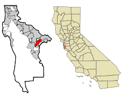
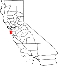
| County | San Mateo | ||
| Incorporated | September 12, 1923[2] | ||
| Named for | Faxton Dean Atherton[2] | ||
| Government[3] | |||
| - Type | City | ||
| - Mayor | Jerry Carlson | ||
| - City council |
Council Members
Kathy McKeithen (Vice Mayor)
Charles E Marsala Jim Dobbie Elizabeth Lewis |
||
| - State Assembly | Ira Ruskin (D) (21st) | ||
| - State Senate | Joe Simitian (D) (11th) | ||
| - U.S. House | Anna Eshoo (D) (14th) | ||
| Area[4] | |||
| - Total | 4.93 sq mi (12.8 km2) | ||
| - Land | 4.90 sq mi (12.7 km2) | ||
| - Water | 0.03 sq mi (0.1 km2) | ||
| Elevation[1] | 59 ft (18 m) | ||
| Population (2000)[4][5] | |||
| - Total | 7,194 | ||
| - Density | 1,467.6/sq mi (566.6/km2) | ||
| US Census Bureau | |||
| Time zone | PST (UTC-8) | ||
| - Summer (DST) | PDT (UTC-7) | ||
| ZIP code[6] | 94027 | ||
| Area code[7] | 650 | ||
| GNIS feature ID[1] | 1657960 | ||
| Website | http://www.ci.atherton.ca.us/ | ||
Atherton is an incorporated town in San Mateo County, California, United States. Its population was 7,194 at the 2000 census. It is one of the wealthiest cities in the United States.[8]
Contents |
History
In 1866, Fair Oaks (Atherton) was a flag stop on the California Coast Line of the Southern Pacific Railroad between San Francisco and San Jose for the convenience of the owners of the large estates who lived north of Menlo Park. The entire area was called Menlo Park. It had been part of the Rancho de las Pulgas that had covered most of the area, which is now southern San Mateo County. There were several attempts to incorporate Fair Oaks, one in 1874 and another in 1911.
In 1923, Menlo Park wished to incorporate its lands to include the Fair Oaks lands. During a meeting of the representatives of the two communities, it became clear to the Fair Oaks property owners that in order to maintain their community as a strictly residential area, they would have to incorporate separately. Both groups rushed to Sacramento but the Fair Oaks committee arrived first. It was at that time they realized that they could not keep the name Fair Oaks, as it was already the name of a town near Sacramento. It was decided to honor Faxon Dean Atherton who had been one of the first property owners in the south peninsula and name the Town for him. Atherton was incorporated on September 12, 1923.
Faxon D. Atherton, a native of Massachusetts, had spent several years in Chile and Hawaii as a trader in tallow, hides and merchandise. His friend and business associate, Thomas Lark had written to him "there is education available for your children and a dignity of living on landed estates down the San Francisco peninsula (that is) convenient and accessible." Atherton purchased 640 acres (2.6 km²) for ten dollars an acre ($2470/km²)in 1860. His home, "Valparaiso Park", was built several years later. It was simple in design and ample for his family of seven children.
Because of the development of the railroad, other San Franciscans traveled south and established summer homes. Because the dirt roads were usually impassable in the winter, the families were only in residence from May through September.
Thomas H. Selby purchased 420 acres (1.7 km²). A successful businessman, he served as mayor of San Francisco. His country estate was called "Almendral". John T. Doyle, an attorney, built a home off Middlefield Road, "Ringwood". James C. Flood purchased successive parcels and built an extravagant mansion, "Linden Towers".This is now Lindenwood. The Joseph A Donohoe estate was "Holmgrove" and is now the site of Menlo Atherton High School. James Thomas Watkins' home was "Fair Oaks" and after two moves, stands restored today on Alejandra Avenue.
The government was established with Edward E. Eyre as the first mayor. In 1928, the residents voted to build a Town Hall, which stands today. The early residents wanted a Town that would be divided into large parcels and would not contain businesses. The author Gertrude Atherton, daughter-in-law to Faxon D. Atherton wrote in "The Californians", "Menlo Park (Atherton) has been cut up into country places for what might be termed the 'old families of San Francisco', the eight or ten families who owned the haughty precinct were as exclusive, as conservative, as any group of ancient country families in Europe." A few of the large land holdings were subdivided during the 1920s and 1930s, James Flood estate in 1938. In the 1940s and 1950s over eighty subdivisions were recorded. With the minimum size of one acre (4,000 m²), the era of the large estates was over. Atherton is still a "plain of oaks". Native live oaks, white oaks, bays, redwoods, cedars, pines and other ornamental trees cover the six square miles (16 km²) of town. There are approximately 50 miles (80 km) of roads. The population is around 7500 with approximately 2500 households.
By 1936, ridership on the Southern pacific Coast Line was sufficient that there were 23 round trips between Atherton and San Francisco, a distance of 28 miles (45 km)[9]
Olive Holbrook-Palmer left Holbrook-Palmer Park, a 22 acre (89,000 m²) park, to the Town in 1958. It is an open, tree-covered park, which offers recreational programs and has facilities for functions.
This is also the town of the fictional character Hillary Whitney from the 1988 film, Beaches.
Geography
Atherton is located at .[10]
According to the United States Census Bureau, the town has a total area of 4.9 square miles (12.8 km²), of which, 4.9 square miles (12.7 km²) of it is land and 0.04 square miles (0.1 km²) of it (0.61%) is water.
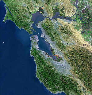
Atherton lies two miles (3 km) southeast of Redwood City, and 18 miles (29 km) northwest of San Jose. The town is considered to be part of the San Francisco metropolitan area.
Culture and contemporary life
There are a number of active community organizations; the Atherton Heritage Association, the Atherton Arts Committee, the Atherton Tree Committee, the Friends of the Atherton Community Library, the Holbrook-Palmer Park Foundation, the Atherton Dames, the Police Task force, and the Atherton Civic Interest League. There are also home owners' associations. The Menlo Circus Club is a private club with stables and a riding ring located within the town.
Government
Atherton's current land use goal is "To preserve the Town's character as a scenic, rural, thickly wooded residential area with abundant open space."[11]
In the state legislature Atherton is located in the 11th Senate District, represented by Democrat Joe Simitian, and in the 21st Assembly District, represented by Democrat Ira Ruskin. Federally, Atherton is located in California's 14th congressional district, which has a Cook PVI of D +18[12] and is represented by Democrat Anna Eshoo.
Demographics
| Historical populations | |||
|---|---|---|---|
| Census | Pop. | %± | |
| 1930 | 1,324 |
|
|
| 1940 | 1,908 | 44.1% | |
| 1950 | 3,630 | 90.3% | |
| 1960 | 7,717 | 112.6% | |
| 1970 | 8,085 | 4.8% | |
| 1980 | 7,797 | −3.6% | |
| 1990 | 7,163 | −8.1% | |
| 2000 | 7,194 | 0.4% | |
| [5][13] | |||
As of the census of 2000, there were 7,194 people, 2,413 households, and 1,984 families residing in the town.[5] The population density was 1,467.6 people per square mile (566.9/km²).[4] There were 2,505 housing units at an average density of 511.0/sq mi (197.4/km²). The racial makeup of the town was 85.36% White, 0.70% African American, 0.17% Native American, 9.79% Asian, 0.42% Pacific Islander, 1.00% from other races, and 2.57% from two or more races. Hispanic or Latino of any race were 3.98% of the population.[5]
There were 2,413 households out of which 33.3% had children under the age of 18 living with them, 75.6% were married couples living together, 4.5% had a female householder with no husband present, and 17.8% were non-families. 12.8% of all households were made up of individuals and 7.5% had someone living alone who was 65 years of age or older. The average household size was 2.85 and the average family size was 3.06.[5]
In the town the population was spread out with 23.7% under the age of 18, 7.2% from 18 to 24, 18.7% from 25 to 44, 30.3% from 45 to 64, and 20.2% who were 65 years of age or older. The median age was 45 years. For every 100 females there were 93.6 males. For every 100 females age 18 and over, there were 90.2 males.[5]
The median income for a household in the town was in excess of $200,000, as is the median income for a family. Males had a median income of over $100,000 versus $68,393 for females. The per capita income for the town was $112,408. About 0.8% of families and 1.7% of the population were below the poverty line, including 0.6% of those under age 18 and 3.3% of those age 65 or over.[5]
Contrary to most of San Mateo County, 55% of Atherton voters are registered Republicans and 27.8% are registered Democrats.[14]
Education
Among Atherton's public schools, Encinal, Las Lomitas, and Laurel are elementary schools, while Selby Lane is both an elementary and a middle school. Menlo-Atherton is a high school. Atherton does not have its own public school system. Selby Lane is part of the Redwood City School District, the high school is part of the Sequoia Union High School District, Las Lomitas Elementary School is part of the Las Lomitas Elementary School District, and both Encinal and Laurel are part of the Menlo Park City School District.
Among the town's private schools, St. Joseph's is an elementary and middle school, Sacred Heart Preparatory is a high school, and Menlo School is a middle and high school.
Menlo College is a private four-year college.
Notable residents
- Ty Cobb, Hall of Fame Major League Baseball Player
- Willie Mays, Hall of Fame Major League Baseball Player.[15]
- Bob Weir, of The Grateful Dead and Ratdog, raised in Atherton.[16]
- Clay Dreslough, Game Designer, raised in Atherton.
- Lindsey Buckingham, of Fleetwood Mac[17]
- Tom Proulx, co-founder of Intuit[18]
- Eric E. Schmidt, Chairman and CEO of Google[19]
- Charles R. Schwab, Founder and CEO of the Charles Schwab Corp.[20]
- Timothy C. Draper, Venture Capitalist and Founder of Draper Fisher Jurvetson[21]
- Thomas F. Stephenson, Venture Capitalist, Sequoia Capital[22]
- Jerry Rice, American former football player[23]
- Vivek Ranadive, Chairman, CEO and Founder of TIBCO Software[24]
- Andy Kessler, author of books on business, technology, and the health field
- Guy Kawasaki
- Steve Westly, former State Controller of California[25]
- Meg Whitman, former CEO of Ebay, former Finance co-chair of Republican Mitt Romney's 2008 Presidential Campaign and national co-chair for Republican John McCain's 2008 Presidential Campaign, the Republican nominee for Governor of California.[26]
- Rajeev Motwani, Professor, Computer Science, Stanford University[27]
- Cheryl Burke, Dancing with the stars professional dancer
- Ted Robinson, San Francisco 49ers play-by-play announcer
- Drew Fuller, Actor, known for role on Charmed
- Bobbie Kelsey, Stanford University Women's Basketball Assistant Coach
References
- ↑ 1.0 1.1 1.2 "Feature Detail Report for: Atherton". Geographic Names Information System. US Geological Survey. http://geonames.usgs.gov/pls/gnispublic/f?p=gnispq:3:::NO::P3_FID:1657960. Retrieved 2009-08-21.
- ↑ 2.0 2.1 "Atherton History". Town of Atherton. 2007-04-27. http://www.ci.atherton.ca.us/history.html. Retrieved 2009-08-21.
- ↑ "Agendas/Reports/Minutes - City Council". Town of Atherton. 2008-12-30. http://www.ci.atherton.ca.us/council-info.html. Retrieved 2009-08-21.
- ↑ 4.0 4.1 4.2 "California by Place - GCT-PH1. Population, Housing Units, Area, and Density: 2000:". American Fact Finder. US Census Bureau. 2000. http://factfinder.census.gov/servlet/GCTTable?_bm=y&-context=gct&-ds_name=DEC_2000_SF1_U&-mt_name=DEC_2000_SF1_U_GCTPH1_ST7&-CONTEXT=gct&-tree_id=4001&-geo_id=04000US06&-format=ST-7. Retrieved 2009-06-26.
- ↑ 5.0 5.1 5.2 5.3 5.4 5.5 5.6 "Atherton town, California - Fact Sheet - American FactFinder". 2000 Census. US Census Bureau. http://factfinder.census.gov/servlet/SAFFFacts?_event=Search&geo_id=01000US&_geoContext=01000US&_street=&_county=Atherton&_cityTown=Atherton&_state=04000US06&_zip=&_lang=en&_sse=on&ActiveGeoDiv=geoSelect&_useEV=&pctxt=fph&pgsl=010&_submenuId=factsheet_1&ds_name=DEC_2000_SAFF&_ci_nbr=null&qr_name=null®=null%3Anull&_keyword=&_industry=. Retrieved 2009-08-21.
- ↑ "USPS - ZIP Code Lookup - Search By City". United States Postal Service. http://zip4.usps.com/zip4/citytown.jsp. Retrieved 2009-08-21.
- ↑ "NANP Administration System". North American Numbering Plan Administration. http://nanpa.com/nas/public/npa_city_query_step2.do;nanpaid=z20cKF7WNycJChhrcl2QTf5PqcpThWlMThGYCn15JrtFqXzgHQcw!1335039869?method=displayData. Retrieved 2009-08-21.
- ↑ 1990 CPH-L-126F. Median Family Income for Places with a Population of 2,500 to 9,999, Ranked Within the United States: 1989
- ↑ Official Guide of the Railways, August, 1936.
- ↑ "US Gazetteer files: 2000 and 1990". United States Census Bureau. 2005-05-03. http://www.census.gov/geo/www/gazetteer/gazette.html. Retrieved 2008-01-31.
- ↑ (PDF) Town of Atherton General Plan. Neal Martin & Associates. 2002-11-20. pp. LU–1. http://www.ci.atherton.ca.us/documents/ViewtheAthertonGeneralPlanPartI.pdf. Retrieved 2009-08-22.
- ↑ "Will Gerrymandered Districts Stem the Wave of Voter Unrest?". Campaign Legal Center Blog. http://www.clcblog.org/blog_item-85.html. Retrieved 2008-02-10.
- ↑ Census years 1930 through 1990 are as follows
- Vol. 1. Number and distribution of inhabitants. Total population for states, counties, and townships or other minor civil divisions; for urban and rural areas; and for cities and other incorporated places.. Washington D.C.: US Census Bureau. 1931. p. 138. http://www.census.gov/prod/www/abs/decennial/1930.htm. Retrieved 2009-08-21.
- v. 1 Number of inhabitants. Total population for States, counties, and minor civil divisions; for urban and rural areas; for incorporated places; for metropolitan districts; and for census tracts. Comprising the first series of population bulletins for the States, Territories, and possessions.. Washington D.C.: US Census Bureau. 1941. p. 125. http://www.census.gov/prod/www/abs/decennial/1940.htm. Retrieved 2009-08-21.
- Vol. I. Number of Inhabitants.. Washington D.C.: US Census Bureau. 1951. pp. 1–48. http://www.census.gov/prod/www/abs/decennial/1950.htm. Retrieved 2009-08-21.
- Vol. 1. Characteristics of the Population. Washington D.C.: US Census Bureau. 1961. pp. 6–26. http://www.census.gov/prod/www/abs/decennial/1960cenpopv1.htm. Retrieved 2009-08-21.
- Vol. 1. Characteristics of the Population. Washington D.C.: US Census Bureau. 1971. pp. 6–11. http://www.census.gov/prod/www/abs/decennial/1970cenpopv1.htm. Retrieved 2009-08-21.
- California - Ch. A, B. Washington D.C.: US Census Bureau. 1981. pp. 6–15. http://www.census.gov/prod/www/abs/decennial/1980cenpopv1.htm. Retrieved 2009-08-21.
- Section 1 - Tables 1 through 61. Washington D.C.: US Census Bureau. 1991. p. California 2. http://www.census.gov/prod/cen1990/cp1/cp-1.html. Retrieved 2009-08-21.
- ↑ "Senate District 11". California State Senate. 2004-12-02. http://www.sen.ca.gov/ftp/SEN/senplan/SD11.HTM. Retrieved 2009-08-21.
- ↑ Taylor, Phil (July 11, 2008). "Willie Mays: An American Giant". SI Vault (Time Inc. A Time Warner Company). http://vault.sportsillustrated.cnn.com/vault/article/web/COM1141904/index.htm. Retrieved 2009-06-25.
- ↑ McNally, Dennis. A Long Strange Trip: The Inside History of the Grateful Dead. New York: Broadway Books, 2002. ISBN 0767911857
- ↑ "Lindsay Buckingham with Special Guest Stevie Nicks". Soundstage. HD READY, LLC and WTTW. 2005. http://www.pbs.org/wttw/soundstage/lbuckingham/bio.htm. Retrieved 2009-01-18.
- ↑ Cortese, Amy (1997-08-07). "MY JET IS BIGGER THAN YOUR JET". BusinessWeek (The McGraw-Hill Companies Inc.). http://www.businessweek.com/1997/34/b354180.htm. Retrieved 2009-06-25.
- ↑ Hansell, Saul (August 8, 2005). "Google's Chief Is Googled, to the Company's Displeasure". The New York Times (The New York Times Company). http://www.nytimes.com/2005/08/08/technology/08google.html. Retrieved 2009-01-18.
- ↑ "#58 Charles R Schwab". The 400 Richest Americans. Forbes.com LLC. 2009. http://www.forbes.com/lists/2005/54/AX8B.html. Retrieved 2009-01-18.
- ↑ Palmeri, Christopher; Linda Himelstein (November 6, 2000). "Tim Draper's Voucher Crusade". BusinessWeek (The McGraw-Hill Companies Inc.). http://www.businessweek.com/archives/2000/b3706169.arc.htm. Retrieved 2009-06-25.
- ↑ "Overseers". Hoover Institution. 2004. http://www.hoover.org/about/report/3231131.html. Retrieved 2009-01-18.
- ↑ The Associated Press (June 6, 2001). "Jerry Rice becomes newest Oakland Raider". The Berkeley Daily Planet. http://www.berkeleydaily.org/issue/2001-06-06/article/5297?headline=Jerry-Rice-becomes-newest-Oakland-Raider. Retrieved 2009-06-25.
- ↑ "The Buzz - the week that was". SFGate (Hearst Communications Inc.): pp. K–1 of the San Francisco Chronicle. June 21, 2009. http://www.sfgate.com/cgi-bin/article.cgi?f=/c/a/2009/06/21/LVT7184SGL.DTL. Retrieved 2009-06-25.
- ↑ "Google staffers quiz candidate Obama". USA Today (USA TODAY, a division of Gannett Co. Inc.). 2007-11-15. http://www.usatoday.com/news/politics/election2008/2007-11-15-google-obama_N.htm. Retrieved 2009-01-18.
- ↑ http://www.riponsociety.org/Ripon%20Profile%20--%20Whitman.pdf
- ↑ AP Associated Press (June 8, 2009). "Stanford computer prof. Rajeev Motwani found dead". SFGate (Hearst Communications Inc.). http://www.sfgate.com/cgi-bin/article.cgi?f=/n/a/2009/06/08/financial/f060447D45.DTL. Retrieved 2009-06-25.
External links
 Media related to Atherton, California at Wikimedia Commons
- Town of Atherton Web Page
- Atherton Public Library - a branch of the San Mateo County Library
|
||||||||||||||||||||
|
|||||||||||||||||||||||||